This Pole Star Global article provides a forecast for the 2025 hurricane season, specifically in the Pacific Tropics. The forecasts include sea surface temperature anomalies, ENSO conditions, and predictions for tropical cyclone activity.
Tracking Tropical Cyclones Around the Northern Pacific
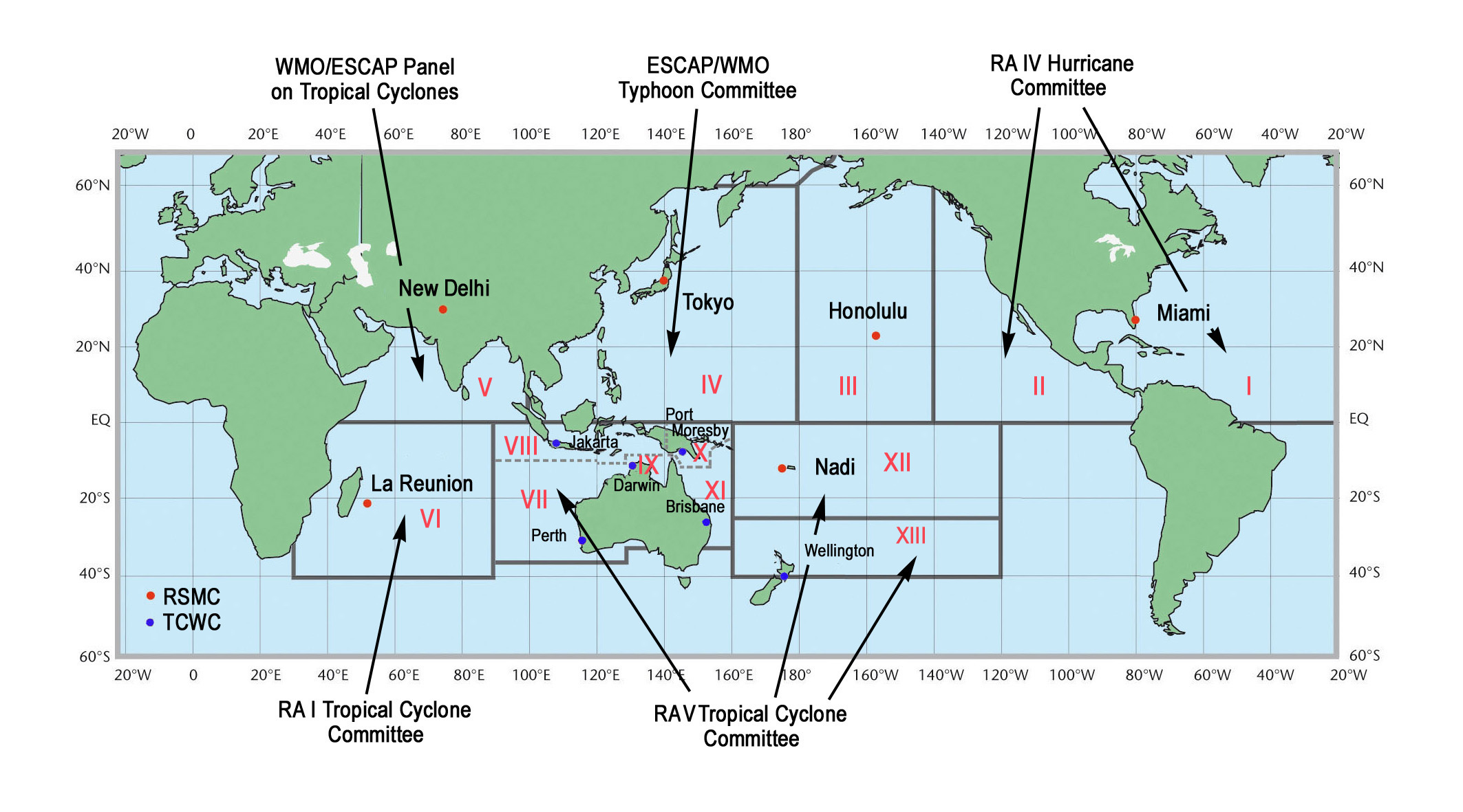
Tropical Cyclones are tracked by specialised weather centres known as Regional Specialized Meteorological Centers (RSMCs) located in various locations around the world. RSMCs monitoring the Pacific region are detailed (see Figure 1).
The Northern Pacific region is divided into three zones, all stretching north from the equator:
- Western Pacific: Covers the area from the International Dateline west to 100°E longitude. This region is monitored by RSMC Tokyo.
- Central Pacific: Spans from the International Dateline east to 140°W longitude, overseen by RSMC Honolulu.
- Eastern Pacific: Ranges from 140°W longitude to the western coast of North America, monitored by RSMC Miami, also known as the National Hurricane Center.
Figure 1: World Meteorological Organization Tropical Cyclone Programme
2024 Hurricane Season Recap
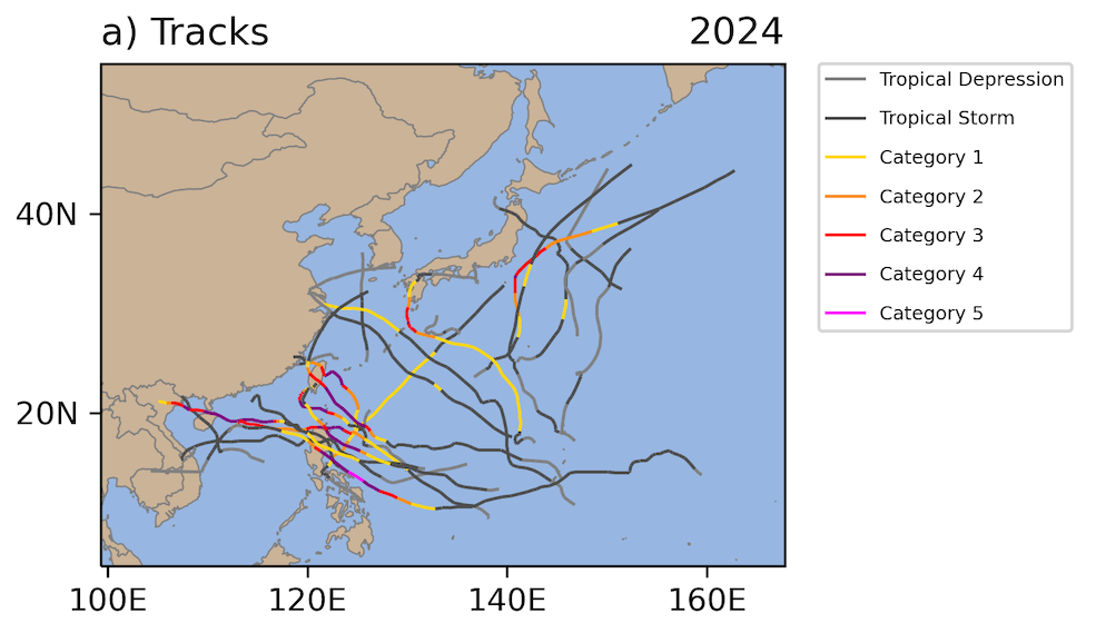
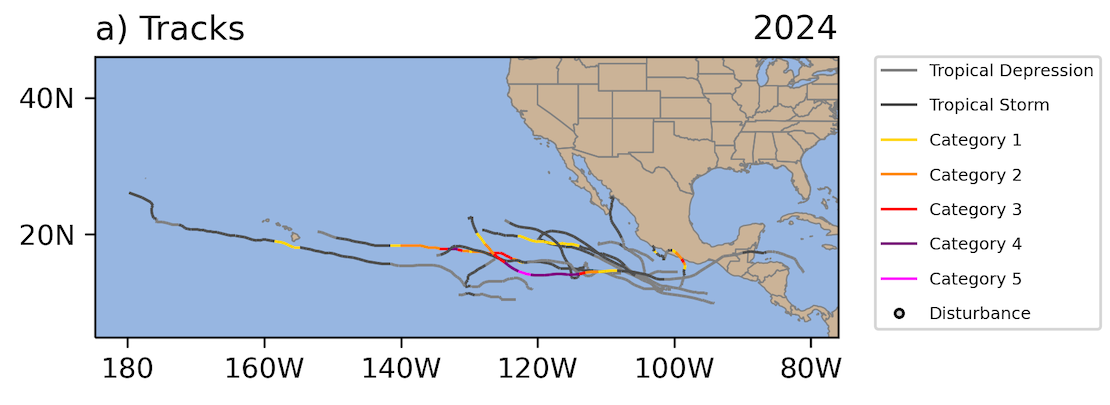
Looking back at the 2024 Tropical Season, the Pacific basin saw a total of 36 Tropical storms, 23 in the Western Pacific and 13 in the Eastern Pacific.
In the Western Pacific, 15 of the 23 named storms became typhoons, with nine reaching major tropical cyclone strength (see Figure 2).
In the Eastern Pacific, five of the named storms developed into hurricanes, with three of those becoming major hurricanes (see Figure 3). Despite this, the Eastern Pacific experienced an overall below-average hurricane season compared to the 1991–2020 average.
Figure 2: Tracks of named tropical systems over Western Pacific for 2024 Tropical Season
ENSO-Neutral Conditions Expected to Influence 2025 Hurricane Season
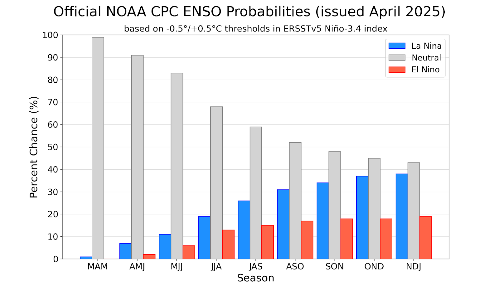
According to The International Research Institute for Climate and Society (2025), there is a high chance that ocean and atmospheric conditions will remain in a neutral phase of the El Niño–Southern Oscillation (ENSO) during the tropical storm season from August to October 2025 (see Figure 4).
ENSO is a climate pattern that affects ocean temperatures and weather. It has three phases:
- El Niño (warmer Pacific Ocean)
- La Niña (cooler Pacific Ocean)
- Neutral (neither warm nor cool Pacific ocean)
While the likelihood of staying in a neutral phase does decrease as the season goes on, it’s still more likely than either El Niño or La Niña forming.
Tracking Sea Surface Temperatures and Their Impact on the 2025 Hurricane Season
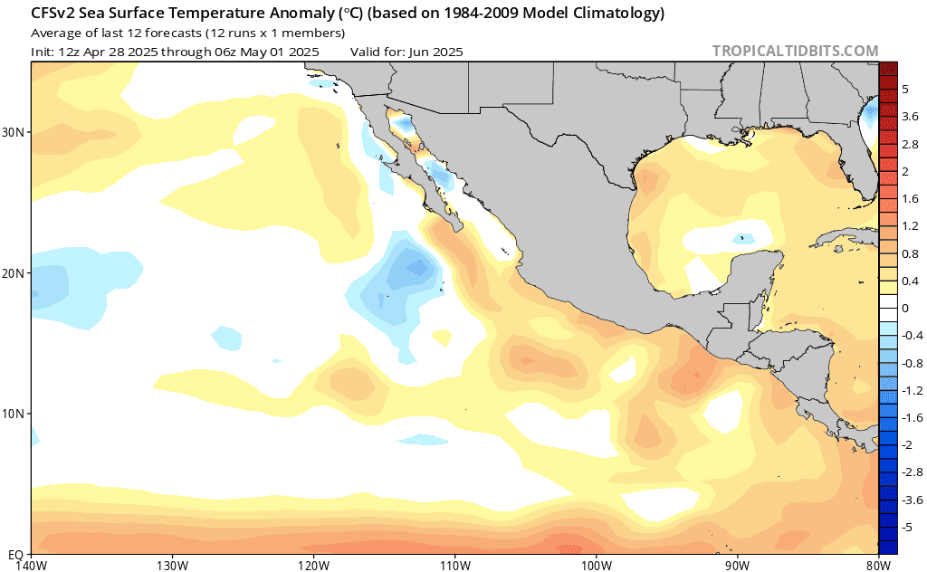
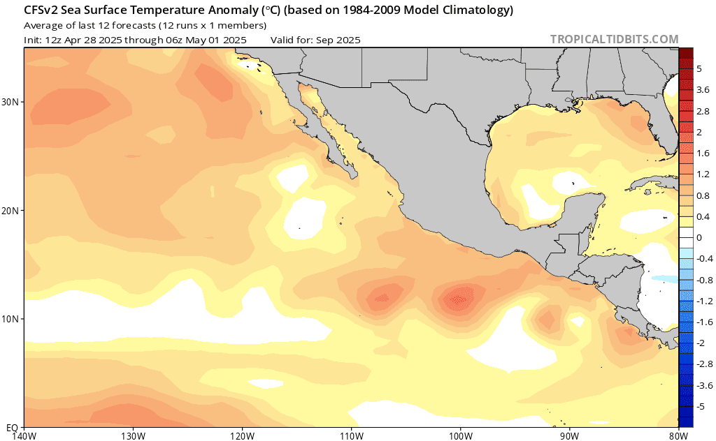
Sea Surface Temperatures (SST) play a major part in tropical storm development. Despite the lack of ENSO influence, as explained above, the Eastern Pacific, especially near the southern coast of Mexico and Central America, is likely to see normal to above normal SST’s as the summer season progresses (see Figure 5 and Figure 6).
However, farther west – past about 110°W longitude toward the central Pacific (the “dateline”) – SST’s will range from near normal to slightly below normal. This area is typically where many tropical storms begin to form (a region called the cyclogenesis zone).
For the West Pacific, SST’s are expected to be warmer than normal (see Figure 7), which typically leads to more tropical storm activity.
East of the Philippines and east-northeastward across the Guam region, you can see a warmer band suggesting this region may see increased storm development.
However, the warmest water temperature anomalies are expected to be farther north, near the Kuroshio current – a major ocean current off the coast of Japan. Warmer waters in that area can lead to increased convection, which often causes wind shear. Wind shear can weaken tropical cyclones or prevent them from growing stronger.

Season Forecast: Slightly Below Average Activity Expected
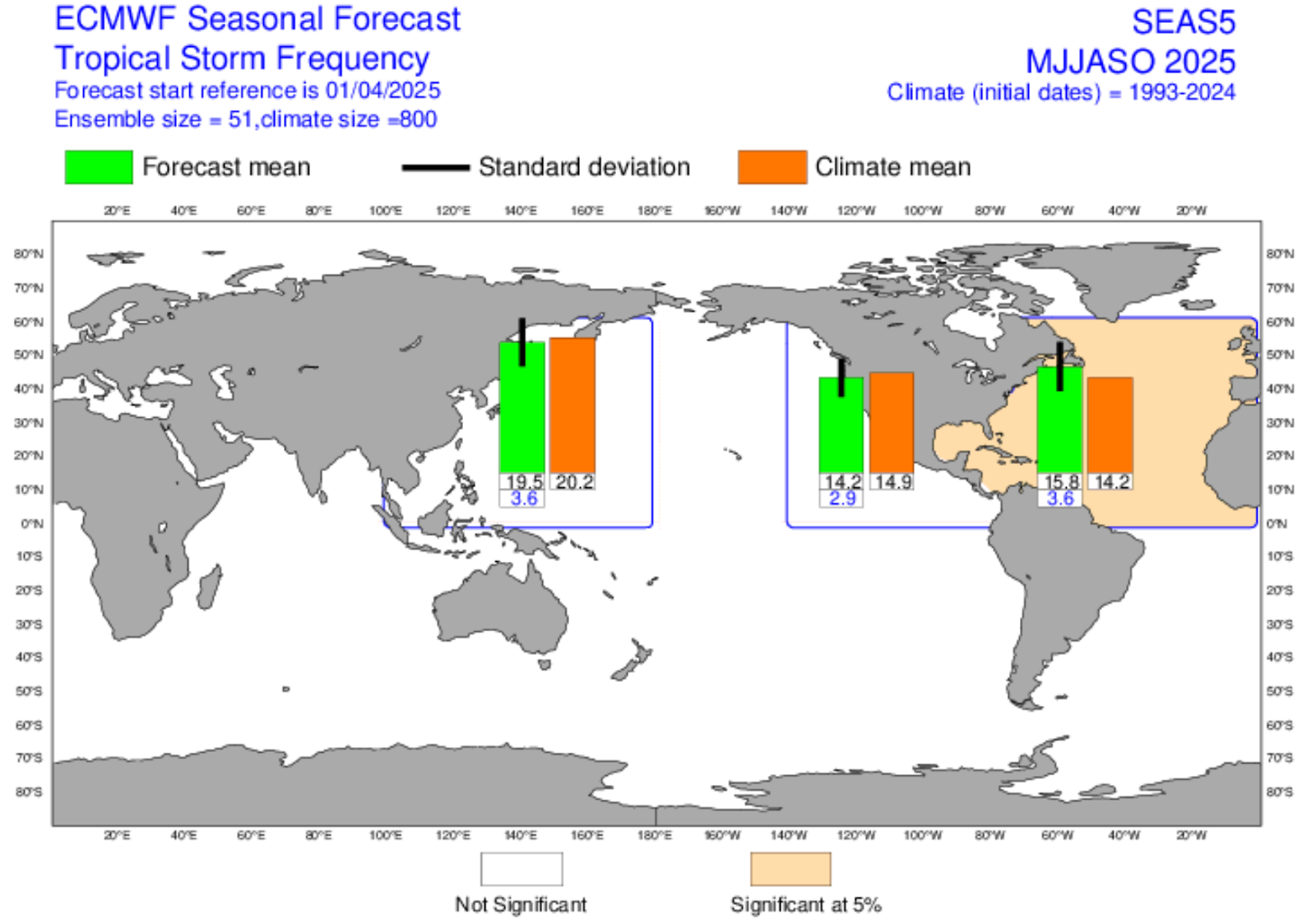
The European Centre for Medium-Range Weather Forecasts (ECMWF) predicts a slightly-lower than average 2025 Tropical Season for both the Western and Eastern Pacific (US EPA) (see Figure 8).
The ECMWF produces a monthly seasonal forecast which estimates how many tropical storms or systems might form over the next six months. Figure 8 shows the forecasts made in April 2025, which cover the period from May through October 2025.
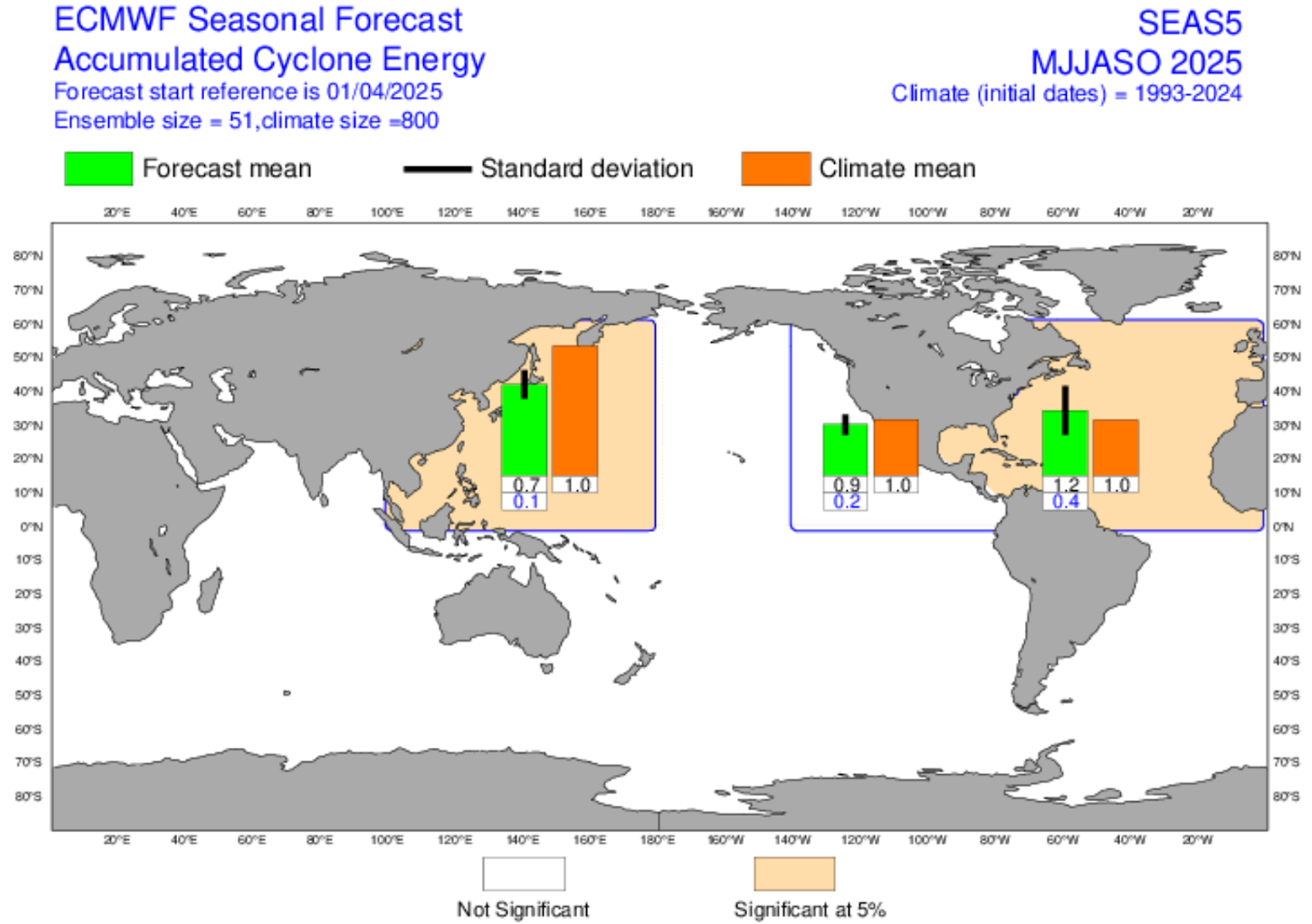
Measuring Storm Power: What the ACE Index Tells Us About the 2025 Hurricane Season
One way scientists measure how active a hurricane or typhoon season might be is by using the Accumulated Cyclone Energy (ACE) Index. This number takes into account both the strength and how long storms last. It is calculated by tracking the maximum wind speeds at six-hour intervals when winds reach or exceed 39 miles per hour.
2025 Pacific Hurricane Season Summary
With a high likelihood of an ENSO-neutral summer, there won’t be strong outside forces either helping or hindering tropical storm development across the Pacific this season. That is, storm activity will mostly depend on local ocean and weather patterns.
Based on this and the above forecasts from the ECMWF, you can expect a near average number of tropical cyclones in the Eastern Pacific. While SSTs are predicted to be above normal, this warming is expected to occur later in the summer and mostly in the far eastern part of the region, which may limit its impacts on the number of tropical cyclones in the Eastern Pacific.
In the Western Pacific, storm activity is also expected to be close to normal. Although the waters will be warmer than usual, the warmest areas are located farther north, outside the main region where storms usually form. This means that tropical cyclones may still form, but they’re likely to be shorter-lived, limiting their overall strength and impact.
Author
Katie LePere is from Westchester County, New York, and has a Bachelor of Science degree in Meteorology from the State University of New York at Oneonta. An accredited Meteorologist (RMet), she has been with FleetWeather Operations Center since November 2013, and is currently a Marine Router on the Atlantic Orcas watch.
About Pole Star Global’s FleetWeather Operations Center
Pole Star Global’s FleetWeather Operations Center is a trusted team of RMetS-accredited marine meteorologists and maritime experts, delivering 24/7 weather routing and forecasting services to the global shipping industry. With over 50 years of experience, they provide both expert advisory and automated solutions to optimise voyage performance, reduce fuel use and emissions, and enhance safety. Their full range of services includes bespoke shoreside and shipside forecasts, advanced seakeeping alerts, multi-route comparisons, and AI-powered optimisation through the Podium platform.