The hurricane season in the Atlantic Ocean runs from June 1st to November 30th, with the climatological peak of the season occurring from mid-August to mid-October. The 2025 Atlantic hurricane season is right around the corner, making it a perfect time to look ahead to know what to expect this year.
For reference, according to the National Hurricane Center (NHC), an average year contains 14 named storms, 7 hurricanes, and 3 major hurricanes (category 3 or higher on the Saffir-Simpson Hurricane Wind Scale). Plus, according to Colorado State University, the average Accumulated Cyclone Energy (ACE) is 123. ACE is an index that measures the season’s overall activity based on the intensity and duration of each storm.
Recapping the 2024 Atlantic Hurricane Season
The 2024 Atlantic hurricane season was more active than usual, fueled by very warm ocean temperatures in the tropical Atlantic. In total, there were 18 named storms, 11 of which became hurricanes. Of those, five reached major hurricane strength – Category 3 or higher on the Saffir-Simpson scale.
The season’s overall strength was also reflected in its ACE index, which hit 161.6.
However, notably, the season included a multi-week lull from late August through early September, during what is typically the peak of the season. Yet, several notable storms occurred on either side of this lull. This included Hurricane Beryl, which in early July became the earliest category 5 hurricane on record in the Atlantic. Another was Hurricane Milton, which struck in early October and ranked among the strongest hurricanes on record in the basin.
Figure 1: 2024 Atlantic Tropical Cyclone Tracks

Previewing the 2025 Season
What Is ENSO and Why Does It Matter for the Hurricane Season?
When predicting how active a hurricane season might be, one of the first things forecasters look at is the El Niño-Southern Oscillation, or ENSO. This is a natural climate pattern centered in the tropical Pacific Ocean that affects weather all over the world – including hurricane activity in the Atlantic.
ENSO can be characterised in three phases:
- El Niño: When sea surface temperatures (SST) in the central and eastern Pacific are warmer than average.
- La Niña: When SST in the central and eastern Pacific are cooler than average.
- Neutral: When SST temperatures are close to average.
These SST patterns influence the atmosphere, especially wind patterns, which can either help or hinder hurricane formation in the Atlantic:
- El Niño: Makes conditions more hostile for hurricanes, mainly by increasing wind shear in the tropical Atlantic. Wind shear refers to a change in wind speed or direction at different heights in the atmosphere. When wind shear is strong, it can disrupt the structure of developing storms by tilting or breaking them apart.
- La Niña: Leads to lower wind shear in the tropical Atlantic, making conditions more favourable for tropical cyclones.
Therefore, knowing what phase ENSO will be in during the peak of hurricane season goes a long way when predicting whether or not the season will be more active than normal.
Where do things stand with ENSO for the 2025 hurricane season?
Back in March, the La Niña that had been in place dissipated, and conditions in the tropical Pacific returned to neutral. This means SSTs for much of the equatorial Pacific were close to average (see Figure 2).
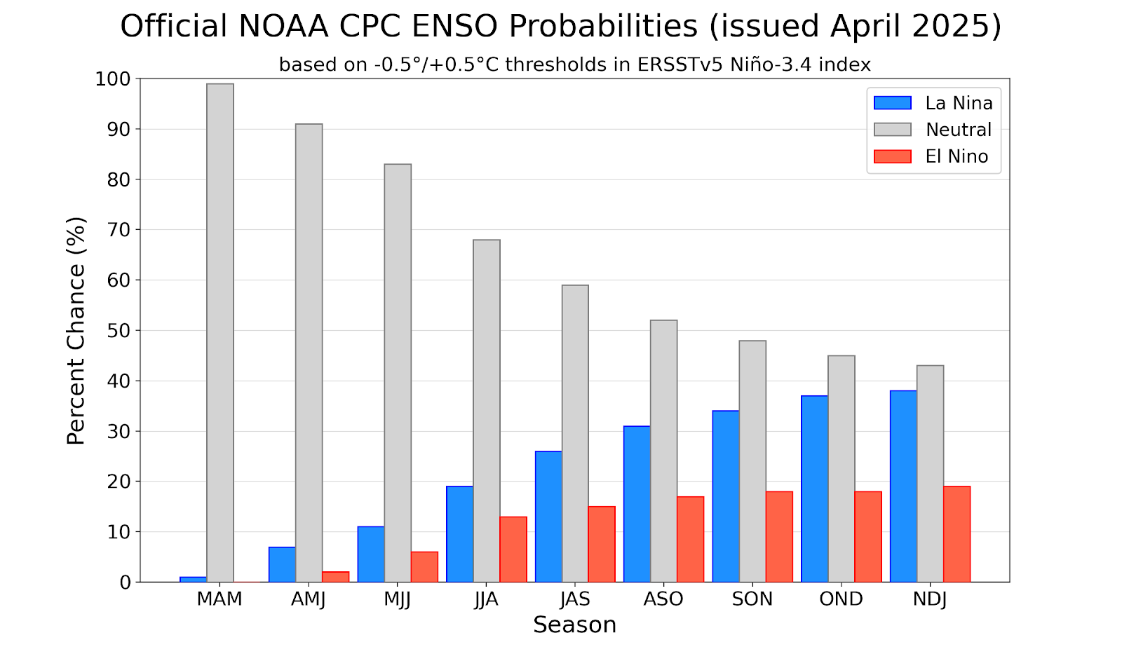
Looking ahead, there’s a chance that La Niña could return later in the hurricane season, but for now, forecasts suggest neutral conditions are most likely to stick around (see Figure 3). Meanwhile, the development of El Niño this year currently seems unlikely.
The presence of either neutral or La Niña conditions, and the absence of El Niño conditions, should result in at least somewhat favourable conditions for tropical cyclone development in the Atlantic.
Figure 2: SST Anomalies in the Pacific as of 26 April 2025
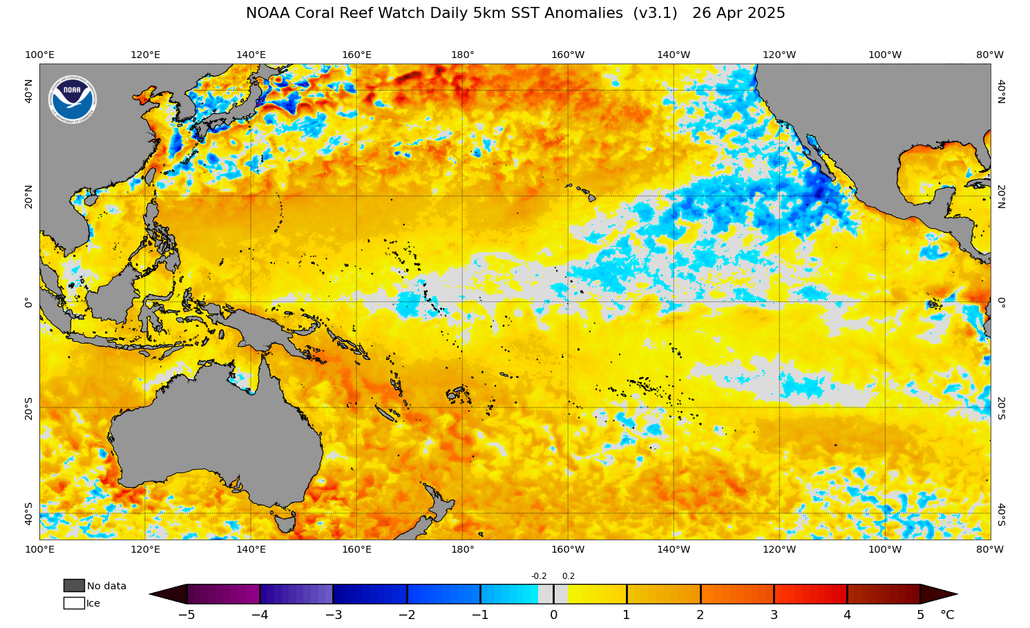
Figure 3: ENSO Phase Probabilities for 2025.
Sea Surface Temperatures (SSTs) in the Atlantic: Why They Matter When Predicting Hurricane Activity
Another key factor to examine when predicting hurricane activity is the SST pattern in the Atlantic, specifically in the area known as the Main Development Region (MDR). The MDR extends from the coast of western Africa across the tropical Atlantic and through the Caribbean. In the Atlantic, most of the tropical cyclones and the vast majority of the major hurricanes develop in the MDR. In particular, an active season generally requires warmer than normal SSTs in the MDR.
Figures 4 and 5 show the current SST anomalies in the tropical Atlantic. A pocket of cooler than normal SSTs exist in the eastern tropical Atlantic near Cabo Verde, with another near the Bahamas. Meanwhile, most of the rest of the tropical Atlantic has above normal SSTs, meaning SSTs are favourable for storm development this season.
Figure 4: SST Anomalies in the Western Tropical Atlantic as of 26 April 2025
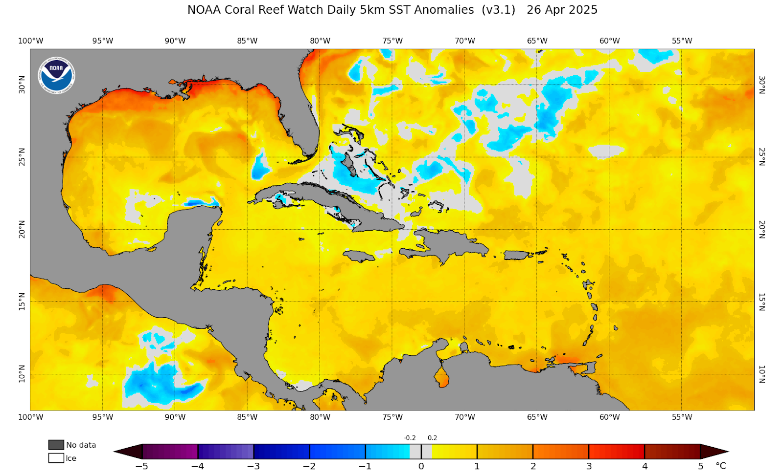
Figure 5: SST Anomalies in the Eastern Tropical Atlantic as of 26 April 2025

Looking Ahead: What Might Ocean Temperatures Look Like During Peak Hurricane Season?
What can you expect during the peak of the hurricane season?
Right now, there is some uncertainty about how ocean temperatures in the Atlantic will evolve.
One forecast model from NOAA (called CFSv2) projects SSTs near or below normal along the coast of Africa and in the southern MDR during the peak of hurricane season. At the same time, this model shows above normal SSTs in the northern half of the Atlantic tropical latitudes (see Figure 6).
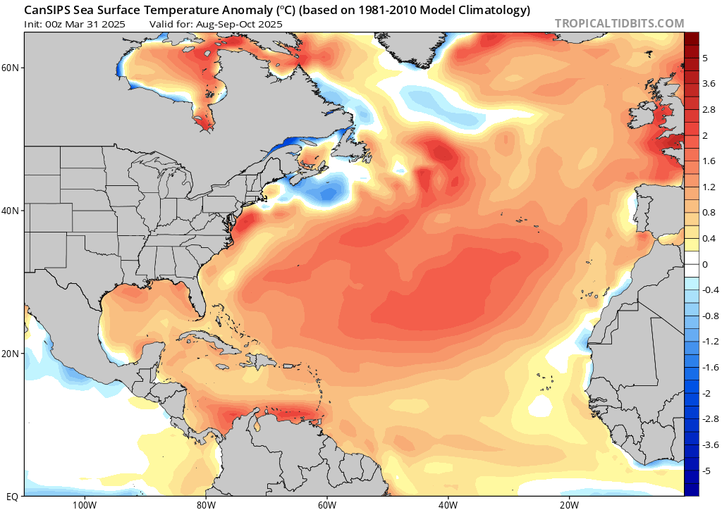
On the other hand, a different model from the Canadian Meteorological Centre (CanSIPS) shows SSTs warming to near or slightly above average in the eastern tropical Atlantic by the peak of the season, with the rest of the MDR also showing above normal SSTs (see Figure 7).
Figure 6: Forecasted SST Anomalies in the Atlantic for August-October 2025, According to the CFSv2 Model
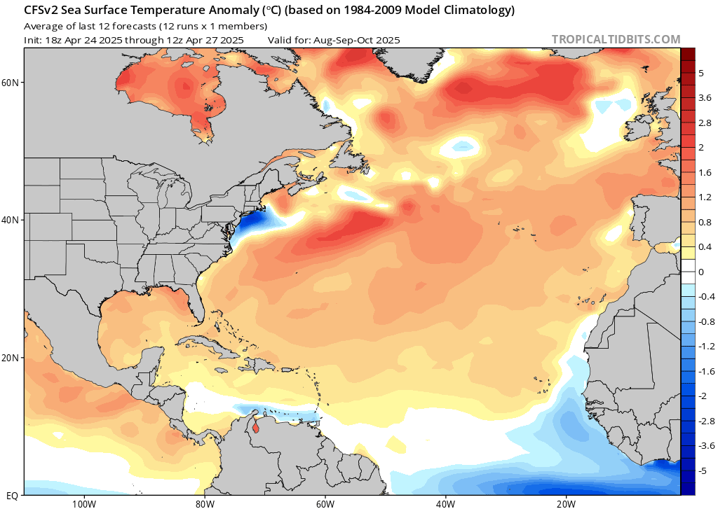
Figure 7: Forecasted SST Anomalies in the Atlantic for August-October 2025, According to the CanSIPS Model
Forecasted Precipitation Anomalies During the 2025 Hurricane Season
We can use the same models discussed above to examine the forecasted precipitation anomalies for the peak of the hurricane season. These precipitation anomaly forecasts can be used as a proxy for the amount of moisture and instability in the tropics. This, in turn, affects how many tropical disturbances might form and how intense they could be.
As shown in the two figures below, the two models have precipitation anomalies closely related to their respective forecasts for SST anomalies. That is, the CFSv2 model shows below normal precipitation in the equatorial Atlantic and the Caribbean, with above normal precipitation along the more northern portions of the tropics (see Figure 8). On the other hand, the CanSIPS model forecasts above-average precipitation for almost the entire MDR (see Figure 9).
Figure 8: Forecasted Precipitation Anomalies for August-October 2025, According to the CFSv2 Model
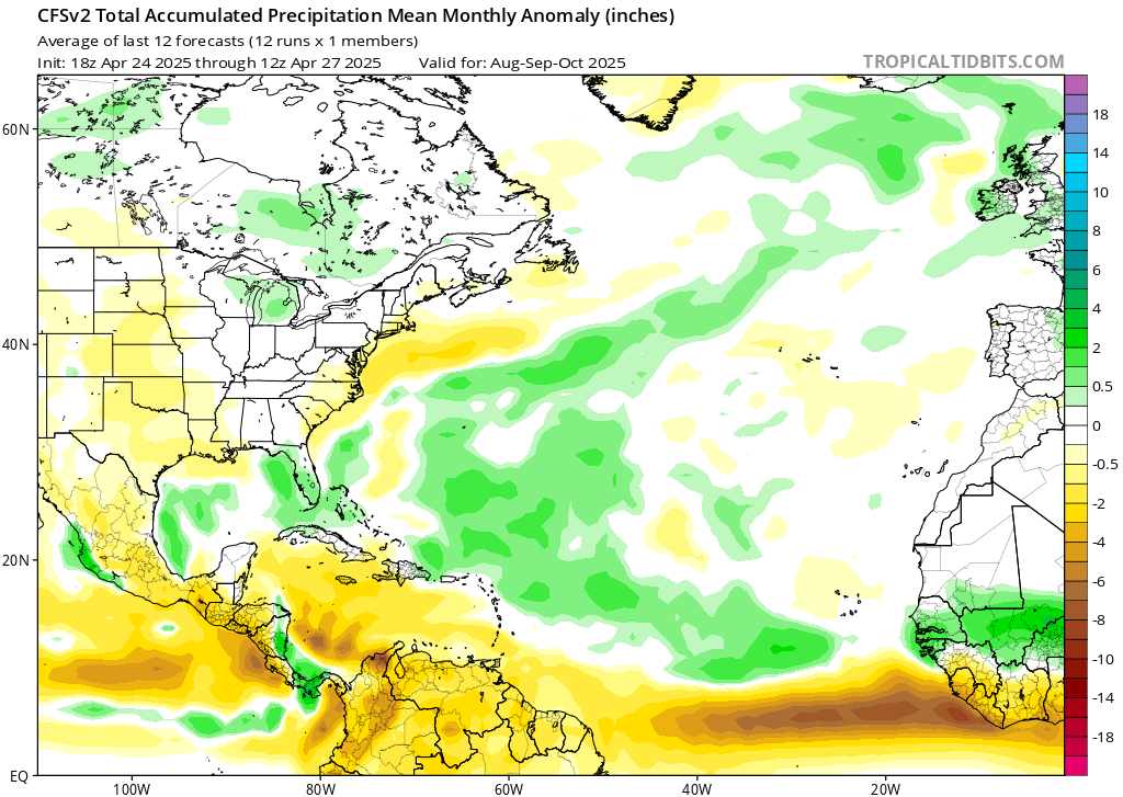
Figure 9: Forecasted Precipitation Anomalies for August-October 2025, According to the CanSIPS Model

2025 Atlantic Hurricane Season Summary
To create the right conditions for tropical cyclones to form, three key ingredients are generally needed: low wind shear, warm SSTs, and adequate atmospheric moisture. As described above, here’s what to expect for each in 2025:
- Wind Shear: The expected presence of either ENSO neutral or La Niña conditions during the 2025 hurricane season will likely lead to near or below normal wind shear in the tropical Atlantic.
- Sea Surface Temperatures (SSTs): There’s still uncertainty about how exactly SSTs will behave, but the MDR should have near or slightly above normal temperatures. However, SSTs are expected to be cooler than they were in 2024.
- Moisture: Moisture and precipitation patterns are also uncertain, but overall seem to be near or above normal as well.
What Does This All Mean for the 2025 Hurricane Season?
Considering all three of these factors together, you can most likely expect the 2025 Atlantic hurricane season to be slightly more active than usual.
This is backed up by the latest ECMWF seasonal forecast. The ECMWF model (a widely used weather model) predicts the Accumulated Cyclone Energy (ACE) will be 1.2 times the normal ACE value in the Atlantic (see Figure 10).
Meanwhile, the April seasonal outlook from Colorado State University similarly projected an ACE value about 1.25 times the normal value.
Given everything mentioned previously, Pole Star Global predicts 18 named storms, 8 hurricanes, and 4 major hurricanes (Category 3 or higher) in the Atlantic this year.
Of course, some uncertainty in the forecast exists at this time. The peak of hurricane season is still a few months away, so a lot can change.
As mentioned earlier, there’s uncertainty over the exact ENSO phase (El Niño, La Niña, or neutral) that will be in place, as well as how sea surface temperatures and moisture levels will behave.
Also, other factors can affect storm development, happening over a shorter period, that are tough to forecast this far in advance. For instance, the Saharan Air Layer, a dry and dust-filled airmass that periodically moves westwards off Africa, can suppress thunderstorm development in the tropical Atlantic during the Spring and Summer when the airmass is strong. Plus, several meteorological patterns fluctuate throughout the hurricane season, leading to temporary higher or lower activity periods. These will have to be monitored throughout the hurricane season.
Figure 10: ECMWF Seasonal ACE Forecast for the Atlantic, East Pacific, and West Pacific Basins

Stay connected, stay safe, and sea clearly with Pole Star Global. Get in touch today to learn more and to speak to a member of our team at [email protected]
Author
![]() Connor Tully is from Hockessin, Delaware. He has a Bachelor’s Degree in Atmospheric Science from the University of Delaware and a Master’s Degree in Applied Meteorology from Mississippi State University. He is an accredited Meteorologist of the Royal Meteorological Society (RMet). He has been with FleetWeather Operations Center since 2019 and is currently a Marine Router on the Pacific Sharks team.
Connor Tully is from Hockessin, Delaware. He has a Bachelor’s Degree in Atmospheric Science from the University of Delaware and a Master’s Degree in Applied Meteorology from Mississippi State University. He is an accredited Meteorologist of the Royal Meteorological Society (RMet). He has been with FleetWeather Operations Center since 2019 and is currently a Marine Router on the Pacific Sharks team.
About Pole Star Global’s FleetWeather Operations Center
Pole Star Global’s FleetWeather Operations Center is a trusted team of RMetS-accredited marine meteorologists and maritime experts, delivering 24/7 weather routing and forecasting, charter party compliance and claims guidance services to the global shipping industry. With over 50 years of experience, they provide both expert advisory and automated solutions to optimise voyage performance, reduce fuel use and emissions, and enhance safety. Their full range of services includes bespoke shoreside and shipside forecasts, advanced seakeeping alerts, multi-route comparisons, and AI-powered optimisation through the Podium platform.