Many experts, including those at Pole Star Global, once again predicted an above-average 2025 hurricane season for the Atlantic basin.
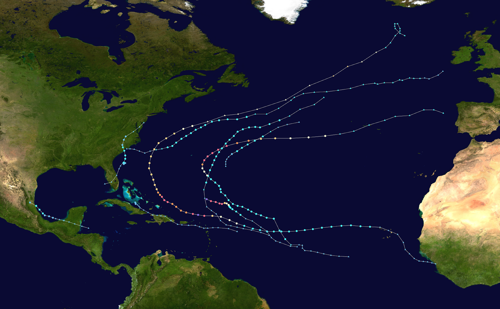
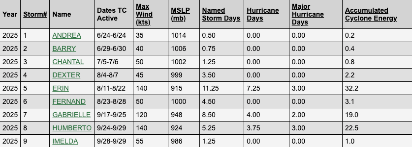
The activity during the average hurricane season typically peaks around 10 September. That date has now passed, and so far activity has been below early expectations. As of the end of September, there have been nine named storms (see Figure 1). Only three storms have grown into major hurricanes: At their strongest over the open Atlantic, Erin reached Category 5, Gabrielle reached Category 4, and Humberto reached Category 5.
On average, about 14 storms form during the Atlantic hurricane season. This year, forecasters expected between 14 and 19 named storms. The key question, therefore, is whether the second half of 2025 will ramp up and deliver the level of activity experts have forecast.
Figure 1
Why the 2025 Hurricane Season Started Quiet And Recently Became More Active
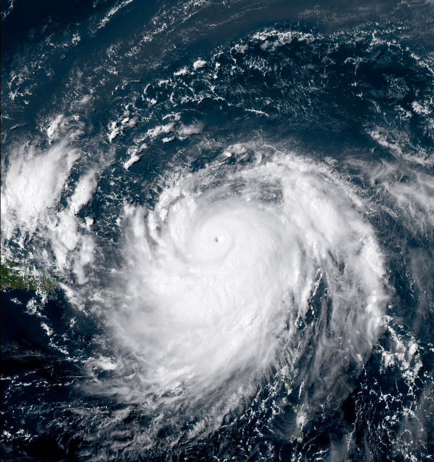
The first half of the 2025 hurricane season has been marked by long stretches of inactivity, interrupted by brief bursts of intensity. By 18 September, only seven tropical cyclones had formed within the Atlantic. Then, in just eleven days, three more tropical cyclones had developed. Of all of these storms, just three, Hurricane Erin, Hurricane Gabrielle, and most recently Hurricane Humberto, intensified into hurricane strength.
Erin rapidly strengthened over the central Atlantic to reach Category 5 strength, with peak sustained winds of 160 mph and a central pressure of 915 millibars. Humberto gradually gained strength as the system moved northwestward over the central tropical Atlantic and eventually topped out at 160 mph sustained winds and a central pressure of 924 millibars.
While Erin and Humberto have highlighted the explosive potential of this year’s warm ocean waters, both storms remained mostly over open seas.
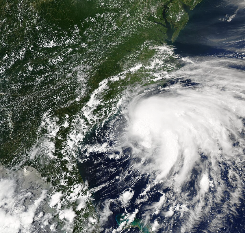
Aside from these three cyclones, the remaining storms struggled to organise, with most either dissipating quickly or recurving away from land. Only Tropical Storm Barry, which came ashore in Mexico, and Tropical Storm Chantal, which brushed the U.S. Southeast, made notable landfalls.
Figure 2
The underlying reason for this relatively quiet season lies in the atmosphere. While sea surface temperatures across the main development region have been consistently above average, these warm waters alone were not enough to fuel storm growth because the surrounding atmospheric conditions were unfavourable.
Throughout much of the first half of the season, dry, dusty air from the Saharan Air Layer spread across the tropical Atlantic. This dry air worked its way into developing storm systems, robbing them of the deep tropical moisture they require to sustain convection. In many cases, tropical waves that initially showed signs of organisation dissipated as they encountered the arid environment.
Compounding the issue has been the presence of unfavourable wind shear across the basin. Vertical wind shear – differences in wind speed and direction at different altitudes – disrupted storm structures by displacing thunderstorms away from their low-level centers, which is essentially the heart of the storm. In multiple cases, this shear tore apart the cores of developing storms, preventing them from strengthening.
Mid-Season Metrics and Forecast Guidance
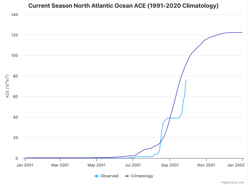
Accumulated Cyclone Energy (“ACE”) is a measure of tropical storm activity in an ocean basin. It takes into account how many tropical cyclones occur, how long they last, and how strong they become. Historically, ACE rises sharply between September and November in the Atlantic Ocean.
As of mid-September, the ACE index stands at 81.4 (Figure 3), far below the climatological average of roughly 95 for this time of year. Most of the activity for this season, 73.7 ACE (or 90%) of the total ACE, has come from just three storms: Hurricane Erin, Gabrielle, and Humberto, respectively.
Figure 3
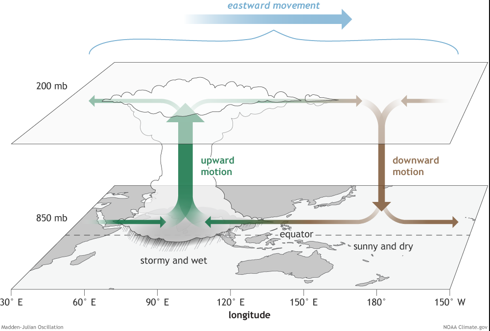
Madden-Julian Oscillation (MJO)
The Madden-Julian Oscillation (MJO) is a climate pattern that causes alternating periods of stronger and weaker convection along the equator. This pattern of rising and descending air moves eastward from the Indian Ocean across the globe.
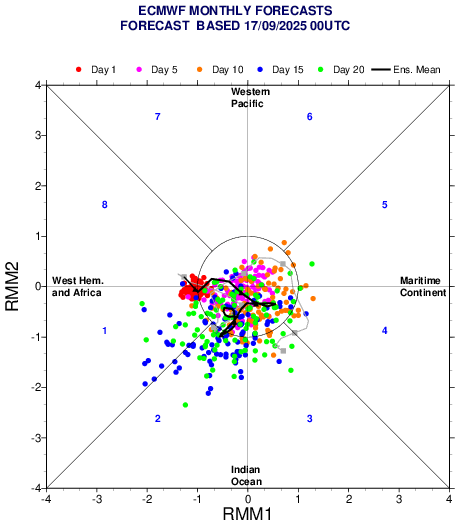
Figure 4
The Madden-Julian Oscillation (MJO) has helped suppress storm activity while in unfavourable phases for much of the season. However, forecasts now show the MJO moving into favourable phases 1 and 2 by late September (Figure 5), which are strongly correlated with elevated Atlantic storm activity. If the MJO remains in these favourable phases through the rest of the hurricane season, the likelihood of multiple storms, including long-track hurricanes developing from African tropical waves, could increase.
Figure 5
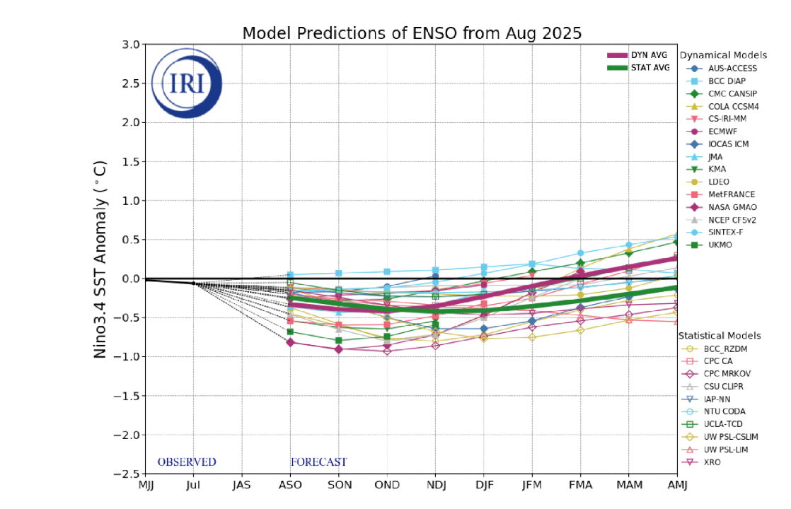
ENSO and Outlook for the Rest of the 2025 Season
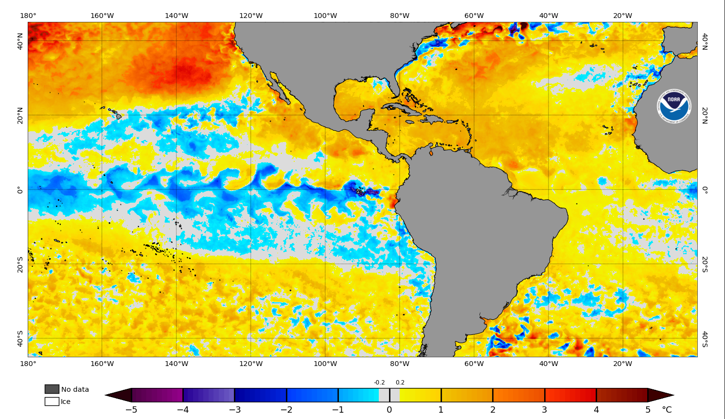
Although the first half of the season has been quiet, the remainder of 2025 still holds the potential to become more active. Several large-scale factors are now aligning to favour hurricane development. Sea surface temperatures across the main development region, the Caribbean, and the Gulf of Mexico remain hot, with anomalies ranging from 1.0 to 2.5°C above average.
At the same time, a strengthening La Niña event is forecast in the equatorial Pacific for the rest of this tropical season and into the winter months (Figure 6). Shear is expected to weaken as the season progresses as a result of a more favourable MJO phase. This will allow tropical waves emerging off Africa to face fewer disruptive winds aloft, allowing storms to organise vertically and strengthen more efficiently.
Figure 6
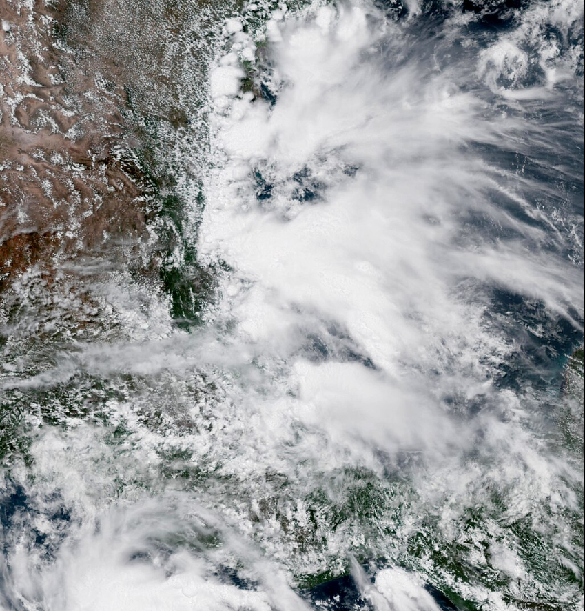
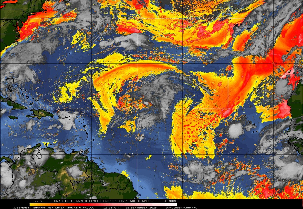
Finally, the Saharan Air Layer (SAL) is retreating across the main hurricane development region. Recent imagery shows Saharan dust continuing to concentrate farther north (Figure 7). Less dry air in the tropical Atlantic means the region is able to maintain moisture, creating a more favourable environment for storm development.
Figure 7
The combination of warm waters across the tropical Atlantic, a strengthening La Niña, and a reduction in Saharan dry air and dust suggests that the second half of the 2025 Atlantic hurricane season could still see an increase in hurricane activity. This is supported by the recent increase in tropical cyclones over the Atlantic, and as we move into October, this active trend may continue.
Looking Forward: Conditions Favour a Busier Second Half
The 2025 Atlantic hurricane season has so far been quieter than pre-season forecasts up to the season’s midpoint on 10 September. However, within the last 30 days, the tropical Atlantic has now seen its second consecutive year with two or more Category 5 storms.
Looking forward, a combination of warm sea surface temperatures, a strengthening La Niña, fewer intrusions of Saharan dry air, and forecasts for favourable MJO phases over the coming months suggests the second half of the season could be much more active. However, given the slower start to the season, even with the recent pick up in activity, the total number of storms may still fall slightly short of earlier expert predictions.
To find out more information or to speak to a member of our team, get in touch at [email protected]. Podium’s FleetWeather team, at Pole Star Global, are here to keep you connected and safe. Receive regular updates to help you navigate changing weather conditions, keeping you one step ahead at all times.