As the official Eastern and Central Pacific tropical seasons ended on November 30th and we close in on the end of the calendar year, now is a good time to highlight the notable systems and analyse the 2024 North Pacific Tropics Season.
Looking Back at the 2024 Mid-Season Pacific Update
First, let’s recap Pole Star’s mid-season update published in September. Our mid-season update mentioned standout systems during the first half of the season, including Super Typhoon Yagi in the Western Pacific, which intensified into the Category 5 equivalent, with 1-minute sustained winds reaching up to 160mph (~140 knots). Yagi tracked from over Luzon Island across the South China Sea towards Hainan Island and the Leizhou Peninsula, and eventually reached northern Vietnam. The Eastern Pacific featured Major Hurricane Gilma that reached Category 4 strength with winds up to 130mph (~115 knots). Gilma remained over open waters during its peak intensity, however it did continue tracking west-northwest towards Hawaii before dissipating.
Second Half of Season Standout Systems
Following in the footsteps of the first half of the season, the latter half featured a few notable cyclones over each of the three basins: the Western, Eastern, and Central Pacific.
Starting out in the Western Pacific, Super Typhoon Krathon (Julian) formed on the 28th of September and tracked northwestward across Luzon Strait while rapidly intensifying, becoming the Category 4 equivalent, with 1-minute sustained winds reaching up to 150mph (~128kts) late on the 30th of September GMT. Krathon then weakened before making landfall as a Category 1 equivalent system along southwest Taiwan on the 3rd of October.
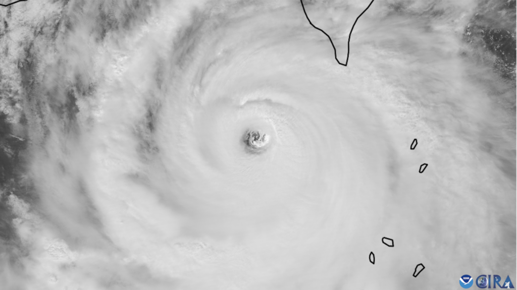
Fig 1: Visible Satellite Image of Krathon on Oct 1st. Source
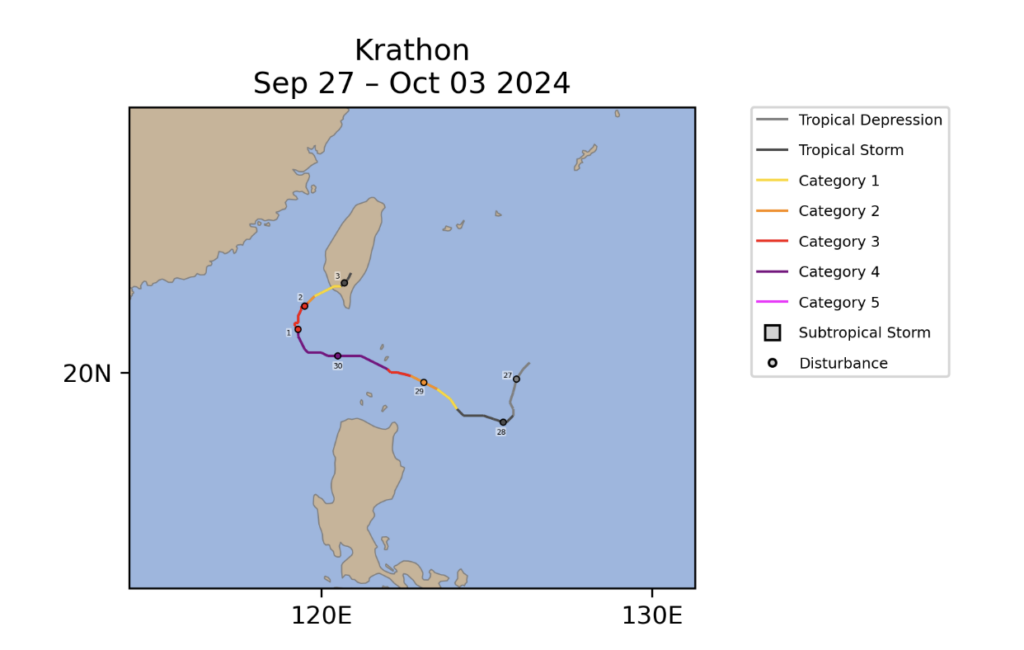
Fig 2: Super Typhoon Krathon Track. Source
Late October and early November for the Western Pacific was also a memorable period during the 2024 season, as five tropical cyclones formed during that timeframe. Kong Rey, Yinxing, Toraji, Man-Yi, and Usagi all developed between 25th October through 11th November. Of the 5 systems, 4 of them were Super Typhoons with Super Typhoon Man-Yi being the strongest as a Category 5 equivalent, with 1-minute sustained winds reaching 160mph (~140kts). Yinxing, Toraji, Man-Yi, and Usagi were all simultaneously active beginning 11 November, which is the first time such has ever occurred in the month of November. Those four storms also added to the total of 6 storms to impact the Philippine Islands over a 30-day period causing about a half billion in damages to the Philippines.
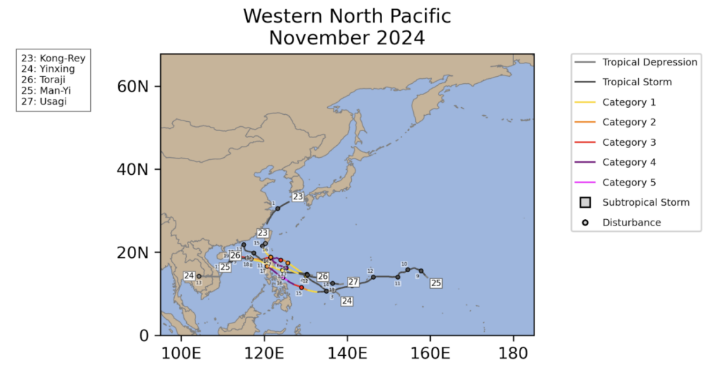
Fig 3: North West Pacific Tropical Cyclone Nov Tracks 2024. Source
In the Eastern Pacific, Hurricane John will be known for the billion dollars in damage it caused over southwestern Mexico. John rapidly intensified on the 23rd September from a Tropical Storm to a Category 3 Hurricane just before landfall northwest of Punta Maldonado, Mexico early on the 24th September.
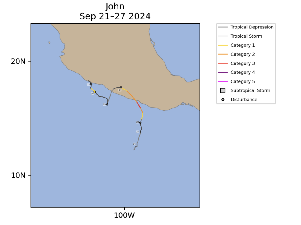
Fig 4: Hurricane John’s Track. Source
Hurricane Kristy formed from the remnants of the North Atlantic Tropical Storm Nadine on the 21st of October. On 24th October, Kristy became a Category 5 Hurricane with 10-minute sustained winds reaching 160mph.
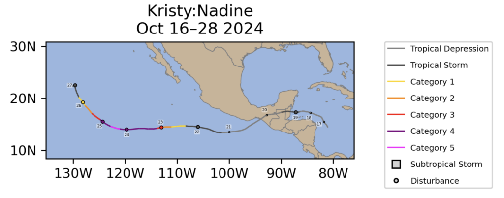
Fig 5: Hurricane Kristy’s Track. Source
In the Central Pacific, on the 22nd of August Hone was designated by the Central Pacific Hurricane Center in Hawaii as a Tropical Storm. Hone would gradually intensify to a Category 1 Hurricane south of the main island of Hawaii by the 25th.
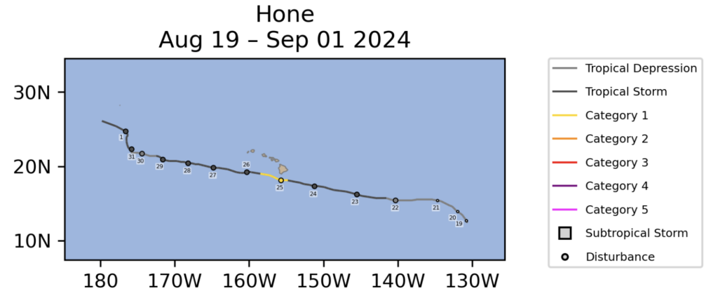
Fig 6: Hurricane Hone’s Track. Source
Reviewing the Numbers
In order to classify how a tropical cyclone season performs as compared to the climatological averages, we typically use 3 categories: above normal, near normal, and below normal. These categories are based on overall storm counts and Accumulated Cyclone Energy (ACE). ACE is a parameter that is used to assess how active the season is taking into account both the intensity and the duration of the tropical cyclones in a season.
Looking back at the Tropical Outlooks prepared by multiple entities, the Western Pacific was projected to be a below average season. However, referencing the below chart we see that based on the number of named storms, typhoons, and super typhoons, the Western Pacific performed as a near-normal season. When accounting for ACE, the season performed below normal. However, it is worth noting that these numbers could change over the next couple of weeks as technically the Western Pacific season remains open.
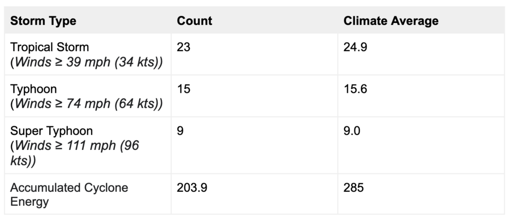
Table 1: North West Pacific Tropical Cyclone Stats 2024. Source
The different outlooks from various sources were split on how well the Eastern Pacific would perform. In Polestar’s May Outlook we predicted an above normal season, whereas the NOAA Outlook predicted a below normal season as seen in the below image.
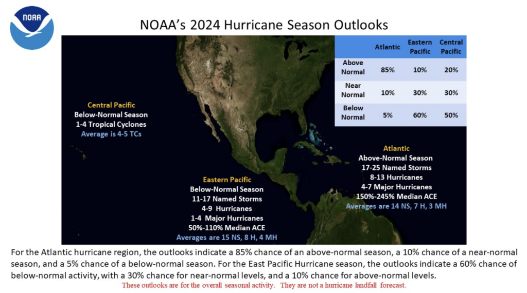
Fig 7: NOAA’s May 2024 Hurricane Season Outlooks. Source
When comparing the numbers to the average seen in the below table, the Eastern Pacific validates as a below normal season.
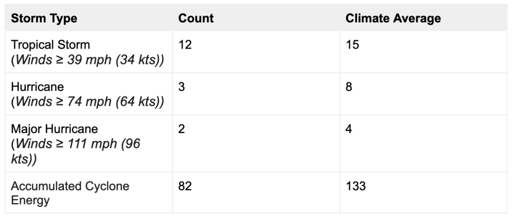
Table 2: North East Pacific Tropical Cyclone Stats 2024. Source
*Note: Source includes 1 cyclone from the central Pacific which was not included in this table.
The Central Pacific was forecasted to be a below average season with the average being 4-5 tropical systems. This validates as there was only 1 named storm for the season.
Wrapping up
The North Pacific basin as a whole has had a slightly below average season compared to the climatological average, with 36 total named storms as of mid-December. This was reasonably predicted by Polestar’s May Outlook. The Eastern Pacific only performed slightly worse than we predicted, primarily due to the late start of the season with the first named system not occurring until July 4th.
The team at Pole Star continues to monitor 24/7/365 across the world providing safe and efficient weather routing to vessels. Please reach out to the team of accredited marine routers at any time to activate Pole Star’s weather routing and forecast services. Pole Star Global is committed to providing optimum guidance to your vessels for any future tropical cyclones or heavy weather that threatens their voyage.
Stay connected and safe, and keep an eye out for our 2025 preseason Pacific tropical outlook in May 2025.