It is not unusual for June to be quiet but as we head in to July there is little change. Tropical Storm Edouard formed on 4 July off the Georgia/N Florida coast and is now an extra-tropical mid-latitude low pressure area headed towards the UK. Edouard was the fifth named Atlantic Storm of the season and breaks the record as the earliest fifth named storm since records began. This year has been slightly different, as most of the named storms have been very short lived and have developed off the US eastern seaboard or Gulf of Mexico. Previously it is unlikely they would have been named at all. Significantly, so far none have reached hurricane strength and no system has yet developed over the more traditional tropical Atlantic.
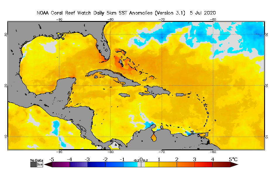
The expectation remains for an above average season, 2020 hurricane season arrives early and could be record breaking. Whilst the Atlantic season runs from 1 June to 30 November, hurricane activity normally peaks in August and September when sea surface temperatures (SST) are at their maximum. Temperatures are already well above seasonal norms. Sea Surface Temperature (SST) anomalies from NOAA’s Coral Reef Watch shows these are running 2-3 Deg C above normal in many parts of the tropical Atlantic, Gulf of Mexico and the Bahamas.

The six basic ingredients for tropical cyclone formation are:
- SST of 26-26.5 Deg C or higher over a water depth greater than 50m,
- low Coriolis Force (5-10S/N of the equator),
- a pre-existing weather disturbance such a tropical wave or cluster of showers and thunderstorms,
- high relative humidity,
- low wind shear not inhibiting development (generally less than 20knots from 5000-30,000ft), and
- a troposphere that is neutrally stable or unstable with respect to rising moist air parcels.
As reported in my recent blog on the present dust plume, Hurricanes and dust in the wind, it looks set to break records as the thickest and densest plume since the start of satellite monitoring in the late 70s. The dust is not sand from the Saharan Desert but consists of fine dust particles that often collect into hollows or flats in the desert landscape. It is then picked up by strong easterly winds between late spring and early fall into what we call the Saharan Air Layer (SAL) and can be up to two miles thick.
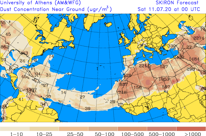
The dust can float for days if not weeks, depending on how high and how dry the air gets. There have been a series of pulses of dust linked to low level wind surges leading to this record breaking plume that now stretches over 6500nm. The SAL helps to suppress the formation and strengthening of tropical cyclones in easterly tropical waves by introducing dry air and bringing vertical wind shear (typically 30-50 knots). While there is convective activity with some of the current waves there is nothing that looks to develop further for now.

Above is the dust concentration forecast from the SKIRON model (University of Athens) for next Saturday still showing a good presence of the SAL in the tropical North Atlantic.
Expect little change over the next week or so to the current pattern. The only areas where storm development may be possible are in the Gulf of Mexico, or north of 20-25N in the west Atlantic off the Florida/Georgia coast away from the SAL influences.
About StratumFive: For more than a decade StratumFive has been delivering leading cost-effective voyage monitoring solutions and now provides services to more than 12,000 ships through its global network, which includes the FleetWeather operations centre in the USA and its 50 year history of service excellence.