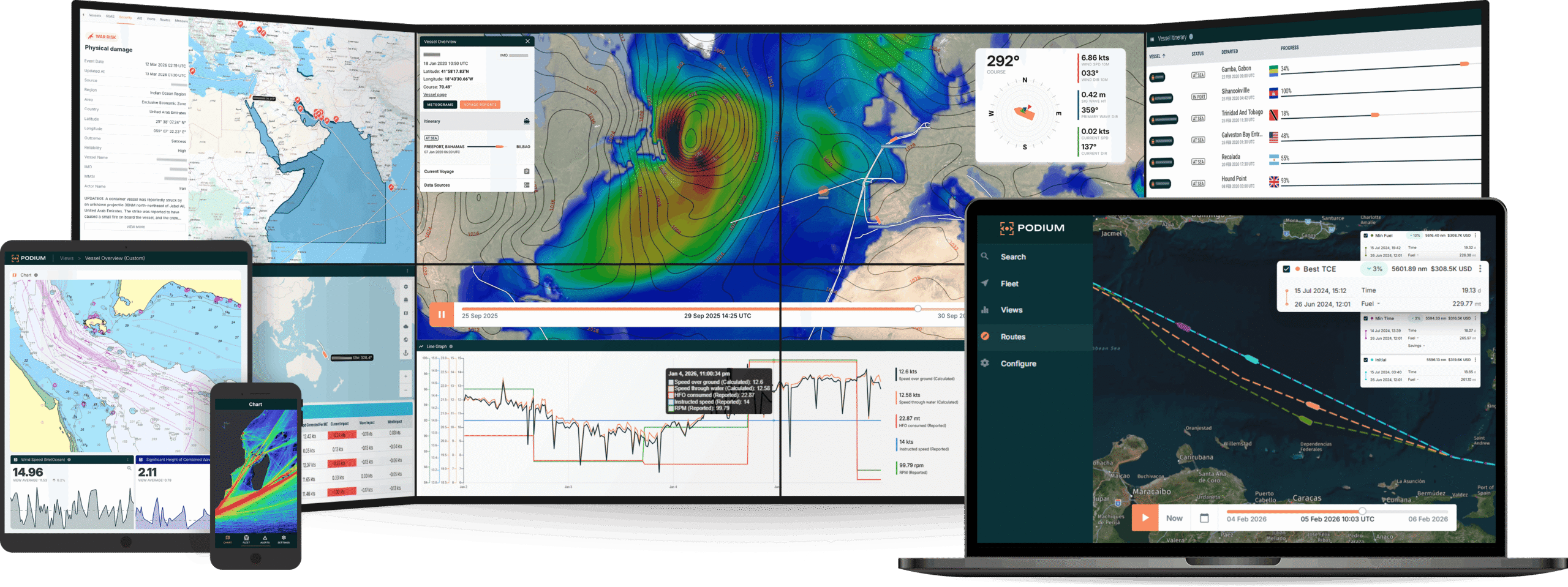

Maritime operators frequently forgo potential savings by adhering to traditional “direct” routes, missing out on cost-saving opportunities when conditions allow for more efficient path optimisation.
Through multi-year data analysis across a diverse array of voyages, Fleetweather, Pole Star’s 24/7/365 team of meteorological experts, has saved 4% on average for trans-ocean voyages by optimising routes for heavy weather avoidance and optimisation of ocean currents. These savings climb to an impressive 6% for voyages during the late winter and spring seasons.
Fleetweather’s accredited marine routing experts can further optimise routes, based on their analysis of several forecast models, ensembles, and climatological data, in combination with Podium5’s powerful Route Optimisation module. This module also encompasses the T-VOS AI-based tool from Theyr, and is part of Pole Star’s comprehensive Podium5 platform, a uniquely flexible and configurable solution offering a range of powerful fleet monitoring capabilities.
With Fleetweather operators can unlock hidden savings simply through smarter routing tailored to each voyage’s unique circumstances.
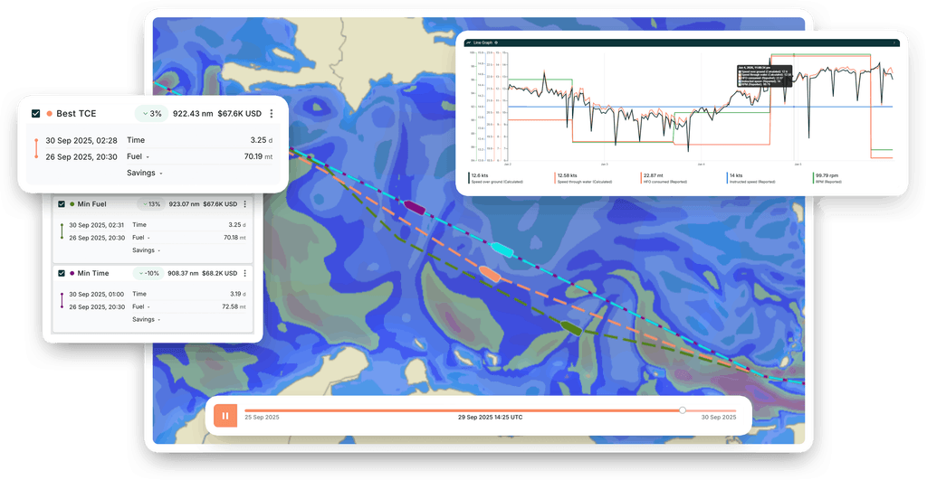
A Traditional or Direct Route is not always Optimal
While it’s common for vessels to utilise weather routing services primarily during heavy weather conditions (such as the Northern Hemisphere winter), there are also gains to be made from applying these services during milder weather. That is, a direct route is not always the most optimal route depending on the circumstances!
Fleetweather doesn’t just keep ships safe from hazardous weather. By leveraging favourable ocean currents and avoiding unfavourable ones, FleetWeather’s optimisation is able to increase the vessel’s speed over ground, saving you time, fuel, and emissions.
To demonstrate the substantial savings unlocked by following the recommendations of Fleetweather’s marine router team two case studies are examined to highlight the power of optimisation, particularly in navigating winter weather patterns and strong currents.
Trans-Pacific Winter Routing Delivers Nearly $50,000 in Savings
In some cases, a master’s intended route may rely on past transits or experiences. Yet, current conditions will vary meaning it’s impossible to apply the same optimal routing assessment for one voyage to another. Rather, independent assessments are vital.
For example, picture this: A Panamax Bulker undertaking a voyage from Balboa to Rizhao in February and March of 2023.
Upon departure, the ship’s master planned to head south of Hawaii. However, after a thorough assessment of the current weather conditions, upcoming forecasts, and long-term climate trends for the transit, Fleetweather proposed a more aggressive route: North of Hawaii, south of Midway Island, and then through Osumi-Kaikyo to the destination.
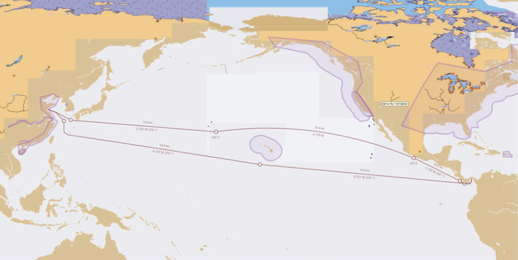
While routing South of Hawaii in mid-winter is feasible and at times necessary, Fleetweather’s analysis has uncovered a more efficient approach. By charting a course through benign weather in the Eastern Pacific, and strategically avoiding the heaviest weather in the Western Pacific, the Panamax Bulker could cover significantly less distance than was originally intended by the master.
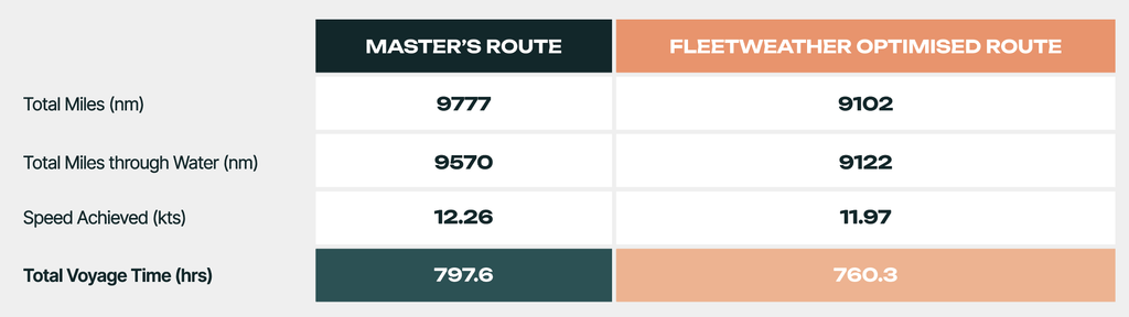
As you will note from the table, Fleetweather’s recommendation resulted in a 675nm shorter distance over ground compared to master’s initial plan. The projected increase in vessel speed (0.29kts higher achieved speed), would not be enough to offset the much longer distance. As such, Fleetweather’s proposed route is estimated to save 37.3 hours on this voyage. With this in mind, and by considering current hire and fuel rates, it’s estimated that these adjustments could save $39,971 in fuel and hire costs!
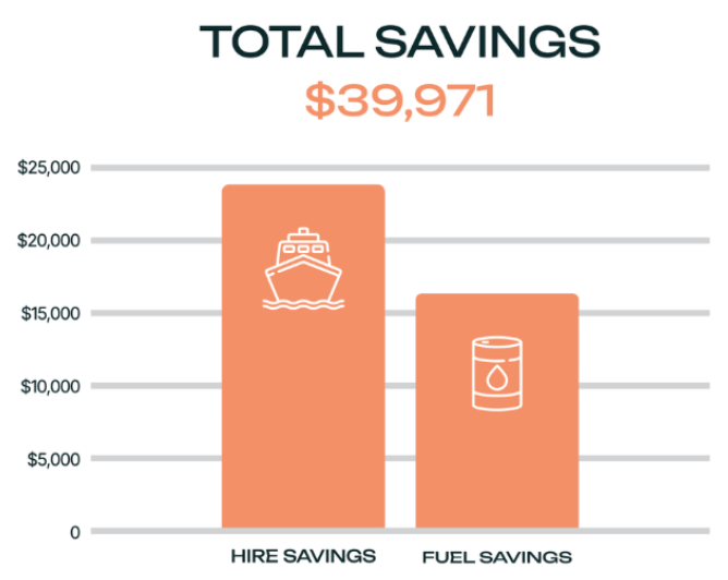
Figure 2 & 3: Route comparison Balboa to Rizhao. This case utilises an instructed speed of 12kts and an average consumption of 20mt/day. Total miles through water takes into account the effects of weather and ocean currents along the route. Savings are based on average hire rates of 16,500USD/day and fuel rates of $704MT/FO (average rates as of May 2024 for Panamax sized bulkers and VLSFO).
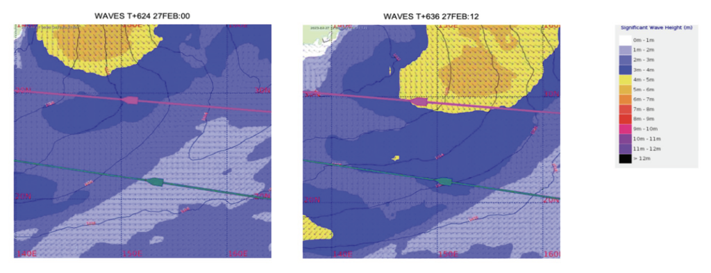
While using climatology data for the ‘average optimal route’ based on time of year can be a good guide, it’s crucial you recognise that what was optimal in January 2023 might not hold true for January 2024.
Hence, evaluating each voyage independently is essential. With this in mind, Fleetweather’s team of marine routers blend historical and climatological data with forecast data, including operational and ensemble model data, to achieve optimal outcomes. This approach ensures not only the safety of the vessel, but also route optimisation tailored to the client’s needs, whether it’s prioritising time, fuel efficiency, or Time Charter Equivalent (TCE) considerations.
Light Weather & Strong Current Routing offers over $21,000 savings
There are many areas of persistently strong ocean currents around the globe that Fleetweather takes into consideration when recommending and optimising routes. These include the Gulf Stream Current across the Western and Central North Atlantic, the North Brazil Current, the Agulhas Current off South Africa, the Kuroshio Current off Japan, as well as strong Equatorial currents, to name a few.
These currents demand route adjustments to either maximise the benefits of favourable currents or to minimise exposure to adverse ones. Such deviations frequently result in significant fuel, cost, and emission savings.
Illustrating this, in the below example, Fleetweather has analysed a voyage of a Panamax bulker, departing from Houston, Texas on 05th May 2024 at a speed of 12kts. They analysed both the direct route via Yucatan Channel (depicted in green), and Fleetweather’s recommended path through the Old Bahama Channel, Mona Passage, and several waypoints north of the North Brazil Current (highlighted in pink).
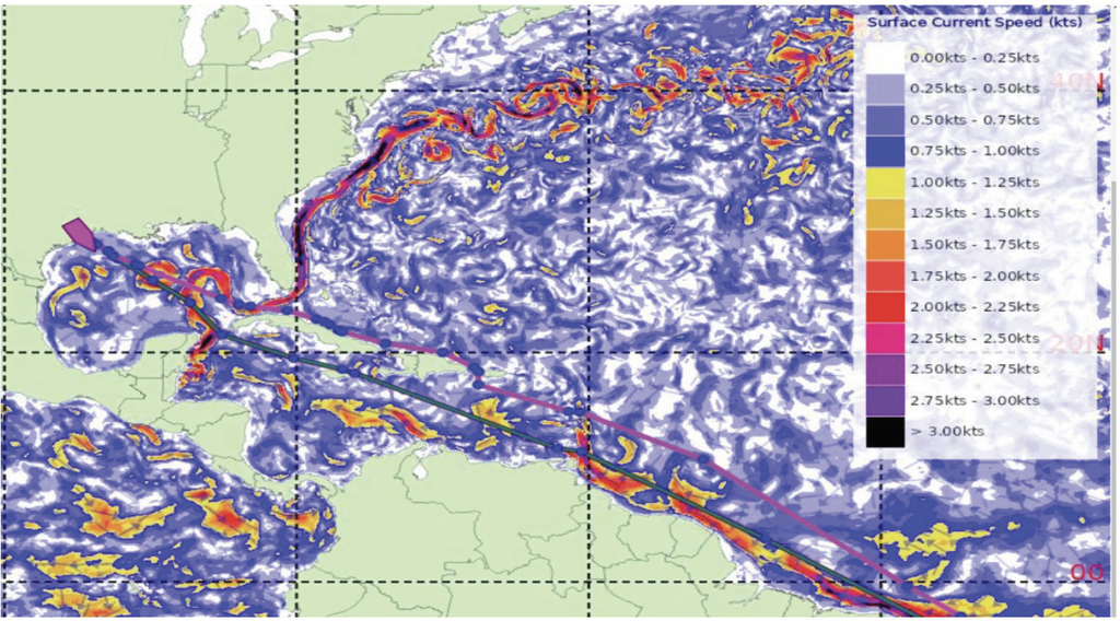
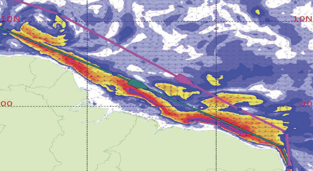
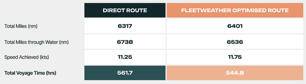
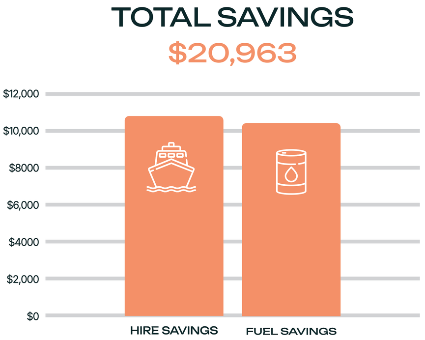
In the table, you can see the recommended route is 84nm longer than a direct route (distance over ground). Yet, when factoring in the more favourable ocean currents on the recommended route, this translates to a 202nm distance reduction over water. This amounts to a time saving of 16.9 hours, representing a +3% improvement with Fleetweather’s guidance. Translating these figures into estimated financial gains, given recent hire and fuel rates, results in savings surpassing $21,000.
Cut Costs, Time & Emissions with Fleetweather
At the heart of Fleetweather’s weather routing service lies the art of optimal route planning. While safety remains the team’s top priority, Fleetweather is able to unlock significant time, cost, and emission savings too.
Route optimisation isn’t a one-time affair – it’s a continuous process. Constant monitoring of short and long-term weather and oceanographic trends is paramount throughout a given voyage, ensuring recommendations remain finely tuned.
Fleetweather’s team of professionally accredited Marine Routers interpret meteorological and oceanographic data, taking into account ship characteristics and cargo requirements, to provide invaluable advice to clients. This advice details why deviating from the traditional route will be beneficial in terms of time, fuel, emissions, and financial savings, all while maintaining the safety of the vessel, crew, and cargo.
The examples showcased here offer a glimpse into the substantial savingsachievable across various ocean basins throughout the year. Stay tuned for more as Pole Star Global’s Podium5 unveils route-saving successes across all vessel types across the globe.
STAY TUNED. STAY CONNECTED. STAY SAFE.
You can find all FleetWeather services on Pole Star Global’s Podium Voyage Informatics Platform – bringing together fleet monitoring, regulatory compliance, performance analytics and voyage optimisation into one uniquely flexible platform.