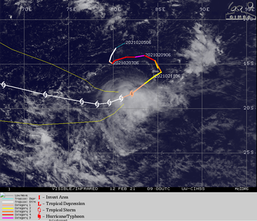
On February 08th, Tropical Cyclone Faraji in the southern Indian Ocean earned the title of the first Category 5 Tropical Storm for the year 2021. Attaining winds of 140 knots, according to the Joint Typhoon Warning Center, as of 09z on February 12th, Faraji is 1400nm east of Port Louis, Mauritius.

Faraji is moving west-southwest at 11 knots, with max sustained winds of 85 knots and significant wave heights of 9-10m. So how did it develop?
Faraji became an official tropical storm on 05th February 1100z. Due to a favourable low wind shear environment and warm sea surface temperatures (SSTs), the system rapidly strengthened as it moved erratically south, then east, helped by favourable upper atmosphere steering and SST of 29 deg C.
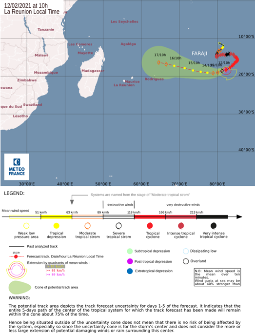
Faraji is now moving over slightly cooler waters of 27-28 deg C with greater wind shear aloft, so will continue to weaken to around 45 knots as it tracks west-southwest and then swing generally west-northwest over the next few days. This high wind shear will prevent the system from intensifying further despite SSTs remaining warm enough. The wind shear is expected to reduce in 4-5 days time leading to possible intensification of back to 45 knots for a short period before weakening thereafter.
This storm remains a threat to shipping, impacting many routes in the Indian Ocean. Its initial erratic movement to the east and south kept the system away from the major shipping trade route between southern Africa and Singapore. There is good numerical model agreement over the track and intensity of the system, so with Faraji poised to track more westward over the coming days it will likely impact this trade route again in 4-5 days time.
The latest accompanying graphic from the Regional Specialised Meteorological Centre (RSMC) La Reunion clearly shows the erratic ‘S’ past track and future swing to the west-northwest. Longer term movement after 17th Feb remains less certain with the models split between going ashore over northern Madagascar or swinging more southerly and dissipating.

Fleetweather is closely monitoring events.
Stay connected and safe.